Copyright Attribution
ArcGIS® and ArcMap® are registered trademarks of Environmental Systems Research Institute, Inc. (ESRI). The software screen shots shown in this page are reprinted with permission from ESRI.
 Homepage Research Staff Publications Useful Links
 In this method example, we will join the car crimes and police beats shapefile datasets. Click [here] to download "car_crimes.zip" and then [here] to download police_beats.zip. Save the two zip archives to the same working folder. Unzip their content and, if necessary, connect the data folder to ArcGIS.
Start ArcMap. Add both the car crimes and the police beats shapefiles as new data layers, using File > Add Data. Right-click on the police_beats layer and select Joins and Relates > Join to bring up the “Join Data” dialog box.
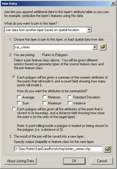
First, specify that you want to "Join data from another layer based on spatial location" and then select the layer which you wish to join to this layer i.e. select the car_crimes layer. The dialog box will confirm that you are joining points to polygons, which is correct.
Second, ensure that the first radio button is selected i.e. "Each polygon will be given a summary of the numeric attributes of the points that fall inside it, and a count field showing how many points fall inside it". Selecting this radio button means that ArcGIS will provide a count of how many points fall within each polygon. If required, it can also calculate summaries of the data based on the attributes of the points which fall within each polygon; since we do not have any attributes for the points in this example we will not select any of the statistical operations.
Third, specify a suitable pathname and filename for the output file e.g. beats_crimes.shp, ensuring that the file will be saved as type "shapefile". Note that you should specify a different name to the input file.
Finally, click "OK".
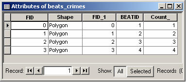
ArcGIS will now carry out an intersect operation to establish within which polygon each point falls. It will then count the number of points (car_crimes) within each polygon and add a field (called COUNT_) to the attribute table of the polygon shapefile and save the output in a new shapefile. The new shapefile (in this case beats_crimes.shp) will be added as a layer to your map. Right-clicking on the new shapefile layer and selecting "Open Attribute Table" will enable you to see the newly created attribute(s). The COUNT_ field now contains the number of car crimes in each polygon in the police beats shapefile.
If you wanted to, you could now map the counts of car crimes per police beat.
ArcGIS® and ArcMap® are registered trademarks of Environmental Systems Research Institute, Inc. (ESRI). The software screen shots shown in this page are reprinted with permission from ESRI.