Map Projections
Map projection is the process whereby positional information related to the earth is transferred onto a
workable surface such as a paper map or computer screen. All maps and geographically referenced datasets
are affected by map projection, even though this may not be apparent to the casual user. As shown in the
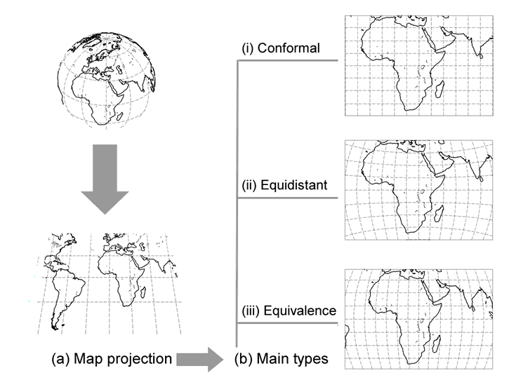
figure, the process involves approximating the shape of the earth using a three-dimensional (3D)
mathematical model and decomposing the 3D coordinates onto a horizontal surface. Through the process of
map projection, every position on the 3-dimenional earth’s surface can be transformed onto a
2-dimensional mapping surface. There are a range of different map projection types, of which three major
ones are illustrated in the figure. The figure shows how the representation of geographical features is
affected by the choice of map projection. For example, there are slight differences in the apparent
outline of Africa between the (i) conformal and (ii) equidistant maps, but the continent is much
elongated in the (iii) equivalence map.
Depending on the scale of the mapping products, the 3D model can be a sphere or a spheroid. The latter
does not have a constant radius like a sphere but is a 3D model formed by rotating an ellipse about its
principal axis. It is a suitable representation of the earth and provides the necessary mathematical
basis for scientists to establish coordinate systems such as the World Geodetic System defined in 1984
(WGS84) used by the Global Positioning System (GPS).
Geographical Coordinates and Datum
While it is convenient to give a geographical position in terms of latitude and longitude, e.g. the
geographical coordinates of Christchurch in the UK and New Zealand are (50.44 N, 1.47 W) and (43.33 S,
172.47 E) respectively, many computer programs and processing algorithms require the input data to be in
a rectangular format such as (X, Y). Unlike latitude and longitude whereby the equator and the Greenwich
Meridian are the agreed reference lines, the initial points of a rectangular coordinate system can only
be determined after the map datum has been established. A map datum is the reference surface upon which
the mapping and surveying of a country or a region is based. It defines the origin from which all
geographical measurements within a region are taken. While there are global datums such as WGS84, most
developed countries establish their own nationwide horizontal and vertical datums for historical and
practical reasons. Mean sea level, for example, has long been used by many national mapping agencies as
a vertical datum for height measurement and levelling. A horizontal datum will normally consist of the
definition of a map origin and orientation as well as a scale factor in order to minimise the distortion
introduced by map projection.
Local Coordinate Systems and National Grids
The consideration of map datums is particularly important in large scale mapping where geographical
positions are often captured and represented in a plane coordinate system, sometimes known as a grid. In
order to maintain continuity and minimize the numerical complexity of coordinate transformation, many
countries elect to adopt a single reference system which is often referred to as a national grid. A
typical example is the British National Grid, used by Ordnance Survey (Great Britain). Within the
British National Grid, locations are expressed by rectangular coordinates commonly known as Eastings and
Northings which are measured in metric units from a false origin in the extreme southwest. Grid
references of varying precision can be specified by varying the numbers of digits used. Users therefore
need to be particularly aware that they may need to convert geographical coordinates obtained in
latitude and longitude to local coordinates before it is possible to link or map their data.
It is important that the datum and coordinate systems chosen in field measurement or data linkage are
appropriate to the intended use of the geographical data. Should data derived from two different systems
be used, GIS software provides functions for re-projection. This type of processing facility is not
usually available via the Web, however some sites do allow the user to convert individual coordinate
pairs. It is also important to bear in mind that no matter how sophisticated GIS may appear, data
manipulation can never put back geographical details that were not part of the original data
collection.
Additional Resources
Below is a selection of websites that allow users to convert a geographical coordinate in latitude and
longitude into its rectangular equivalents in (X, Y).
The Latitude/Longitude Coordinate Entry Form [http://www.nearby.org.uk/coord-ll.cgi]
UK Street Map Coordinate Converter [http://www.streetmap.co.uk/gridconvert.html]
NGS Geodetic to UTM conversion [http://www.ngs.noaa.gov/cgi-bin/utm_getut.prl]
Convert Geographic coordinates to MGA [http://www.ga.gov.au/scientific-topics/positioning-navigation/geodesy/geodetic-techniques/calculation-methods]
 Homepage