Mapping Deprivation Data using SASPAC
In this example you will be able to import the Indices of Deprivation 2007 (or ID2007) to SASPAC and
produce a deprivation map of Newham. It is necessary for users to add the framework data and metadata
manually to the system before the corresponding system file can be opened and used by SASPAC. The system
files containing ID2007 data for all nine regions in England can be obtained from the SASPAC project
site. At the time of writing, the URL is http://www.saspac.org/2007IMD.html.
Importing the 2007 Indices of Deprivation to SASPAC
A detailed User Guidance Note (UGN GE-06) on how to access ID2007 for Super Output Areas using SASPAC
can be found on the SASPAC project site as stated above. For the purposes of this example, the key steps
are outlined here. First, you will need to download two files by clicking the name of the files:
ID2007 update: "ID2007updatefiles.zip"
ID2007-LSOA-London:
"ID 2007 - SUPER OUTPUT AREAS LOWER LEVEL
- LONDON REGION.zip"
Both zip archives should be saved to a local working folder before copying the unzipped content to
different system folders of SASPAC (which are likely to be under "C:\SASPAC\"):
"ID 2007 - SUPER OUTPUT AREAS LOWER LEVEL - LONDON.SYS" to "C:\SASPAC\SYSFILES\"
"ID2007.fwd" to "C:\SASPAC\FRWDATA"
"ID07.FWK" to "C:\SASPAC\FRWORK"
"ID07da.*" to "C:\SASPAC\METADATA"
where * represent the file extensions .CPR, .KEY and .NDX (SASPAC is not sensitive to case when handling
filename)
To complete the updating process, the users will need to add an ID2007 statement to the "saspac.ini"
file which can be found at (assuming Windows XP is the operating system, refer to the full user guidance
note for other systems):
"C:\Documents and Settings\{USERNAME}\Application Data\SASPAC"
Use a text editor to open the INI file. Scroll down to the "[Framework, Table & Cell Metadata]"
section. Insert a blank line immediately below this section header. On the newly-inserted blank line,
input the following text:
2007ID=origin:"SASPAC",fwk:"ID07.fwk",fdesc:"Indices of Deprivation",year:"2007",type:"S",lookup:"ID07DA"
You have now updated SASPAC with ID2007.
Creating a Localised ID2007 System file in MapShore
In the last part of the exercise, we will create a new SASPAC system file that contains a subset of the
ID2007 data covering only the LSOA zones within Newham. The simplified system file can then be used for
further linking and mapping in SASPAC and MapShore.
Start SASPAC. Close the Quickstart task menu if it is launched. Select File > New Task > Create New
System File... and open "ID 2007 - SUPER OUTPUT AREAS LOWER LEVEL - LONDON.SYS" by clicking
the "C:\SASPAC\SYSFILES" button. In the next step we will restrict the area to Newham. Use the
"Select Areas" command and on the "Use MapShore" tab, click the "Run MapShore"
button. In the MapShore window, select Boundary > Retrieve... and open "newham_low_soa_2001.shp"
(note the .SHP file type) ) that should be downloaded at the beginning of the workshop.
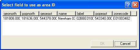
Select "zonecode" (the last column) as the area ID and "name" as the area name to
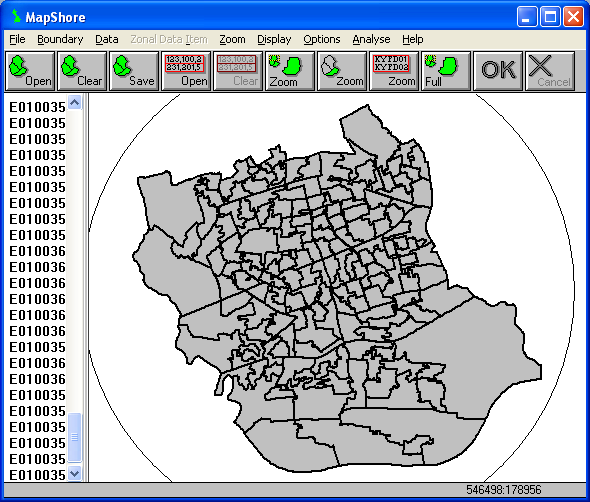
proceed. Select Boundary > Selection > Select Polygons Partly Within Circle. Click and drag a
circle until all the displayed zones are enclosed. Release the mouse button and all the zones will now
be shaded and their zonecodes are listed on the left selection pane.
Return to Boundary > Selection and then select "Export Selected Areas => SASPAC". In the
SASPAC's "Select Areas" window, click the "Add All >>" button followed by the
"Include Selected Zones" command. The two zone lists should now become blank indicating that
the selected zones have been included in the main SASPAC command. Click Close to terminate the area
selection process.
In the "Create New System File" window, click the "Output to..." button. Accept the
default file location (likely to be "C:\SASPAC\SYSFILES") and name the new system file as
"ID2007-LSOA-NEWHAM.SYS". Enter "ID2007" as the system file label.

Click OK and accept all the default settings in the Task dialog box to run the SASPAC commands. When the
process is completed, a new ID2007 system file covering only the LSOA zones in Newham is created in
"C:\SASPAC\SYSFILES\".
Mapping Deprivation Ranking
The deprivation data for Newham can now be mapped. Close the current log file window in SASPAC. Select
File > New Task > Export data > CSV File... to start building up the thematic map. Open the
newly-created Newham-based ID2007 system file ("NEWHAM_KEYSTATS_LSOA.SYS") which should be located at
the default system folder ("C:\SASPAC\SYSFILES\"). Enter "ID20070002" (the IMD ranking
variable) in the "Select Variable Name(s)" textbox. Save the output file as "IDRANK_NEWHAM.CSV"
to the default output file folder ("C:\SASPAC\INTERFAC\"). Click OK and then Yes (when
prompted for adding ZONEID) to continue. In the Task dialog box, accept the default settings and click
OK to run the SASPAC commands.
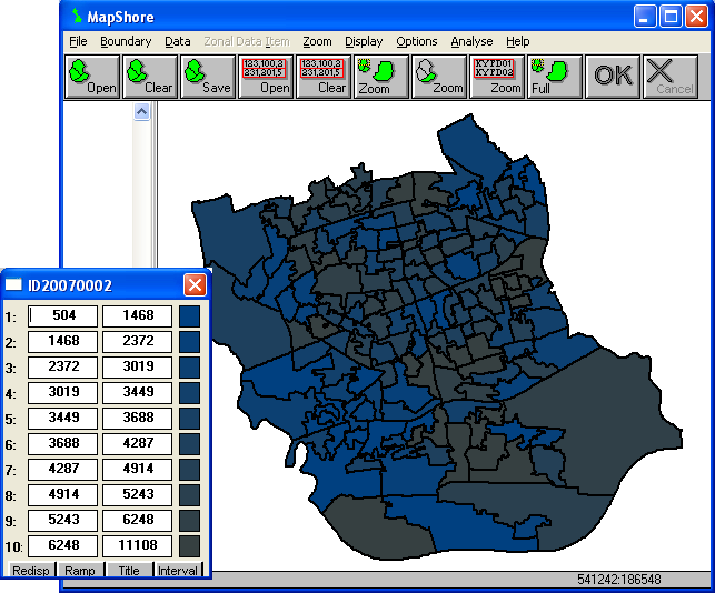
When the process is complete, click the "Go Mapping" button to return to MapShore and the
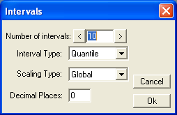
ID2007 data should now be displayed. It is highly unlikely that the data type and range will be
appropriate in the first instance. To adjust the display, click the "Interval" button on the
zonal key (you may need to activate the key via the Display > Zonal Key command) and alter the values
as follows:
Click Ok to apply the changes. Click the "Ramp" and then the "Redisp." buttons on the
key to change the multi-coloured scheme to a graduated shading pattern which is better for mapping
continuous data.
Use the Export or Print commands to generate an output file. If you intend to use the results in future,
save the work to a MapShore Library (.LIB) file.
Copyright Attribution
The Small Area Statistics Package (SASPAC) software is owned by the Improvement and Development Agency
for Local Government (IDeA). MapShore is a registered trademark of Pebbleshore Ltd. The software screen
shots shown in this page are reprinted with permission from IDeA and Pebbleshore Ltd. The maps shown
above are based on data provided through EDINA UKBORDERS with the support of the ESRC and JISC and uses
boundary material which is copyright of the Crown.
 Homepage