Mapping a Set of Points in ArcGIS
For this example, we shall use ArcGIS to map the points. First, we need to get the coordinates into a
format which the GIS is capable of interpreting and importing. ArcGIS is actually capable of importing a
range of file types but one of the most robust and reliable formats for importing a set of point
coordinates is dBASE(IV) format. Our coordinates may be in a range of formats including a simple text
file, a comma-delimited (.csv) file, or a tab-delimited (.tab) file. Coordinates may also have been
processed or edited in other software packages such as Microsoft Excel and saved, for example, as an
.xls file. One of the best ways to get our coordinates into dBASE format is to use Microsoft Access.
Access can import data from all of the above formats.
In this example, our data are available as a text file crime_grefs.txt. You can download the file by
clicking
[here].
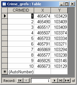
Microsoft Access should be used to provide a unique (ideally numeric)
identifier for each point (e.g. by using the auto-numbering
function in the import wizard), to name each field (preferably
with a name of less than 8 characters and not using spaces,
brackets or dashes), and to define the data type of each
field (e.g. integer, text). Make sure you define the
X and Y fields as numbers/ integers.
This creates a table with three fields: CRIMEID, X, Y.
This table can be exported in dBASE(IV) format by selecting the table, right-clicking and then choosing
"Export". Specify a pathname and suitable filename e.g. "crimes", select Save as type dBASE IV (*.dbf)
and then click "Export". This will create the file CRIMES.DBF (and, probably, some other associated
files such as CRIMES.INF and CRIMES.MDX).
ArcGIS
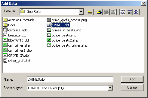
Start ArcMap (with a new empty map). Select File > Add Data. Select your .dbf file and click "Add".
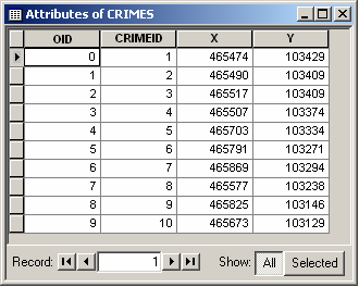
This adds your .dbf file as a Table. You can open the table by right-clicking on it in the Layers Frame
and selecting "Open".
Now, we need to get ArcMap to use the coordinates from the table to create points which we can then map.
We can do this using the Add XY data tool in ArcMap.
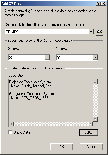
Select Tools > Add XY data. Specify that we wish to use CRIMES as the table from which the coordinates
will come and then select the fields which contain the X and Y coordinates of the points (in this case,
X and Y respectively). At this point, we can also specify the coordinate system and/or projection for
the points. In this example, the coordinate system is the British National Grid. Select "Edit", then
"Select" (to select a pre-existing coordinate system) and then browse until you find "British National
Grid.prj" (under Projected Coordinate Systems > National Grids); click "Add" and then "OK". This gives
ArcMap all of the information it needs to map the coordinates. Click "OK". ArcMap will automatically map
the points in the Data Frame.
These features (points) are not yet permanent though. If you were to close ArcMap now, they would not be
saved. To create a permanent dataset of the points, you need to convert the points to, for instance, a
shapefile or a feature class. We will create a shapefile. Right-click on the CRIMES Events layer in the
Layers frame and then select Data > Export Data. Choose to save all features; specify that you wish to
use the same coordinate system as the layer's source data; browse to the relevant directory and provide
a suitable filename e.g. car_crimes.shp (Note that because both dBASE and some ArcGIS files use the
extension .dbf, things can get a little confusing! It is best therefore, to name the shapefile something
different to the name you used for the .dbf file previously); leave the 'Save as type' as "shapefile";
click "Save"; and finally "OK". ArcMap will ask if you want to add the exported data as a map to the
layer - say "Yes".
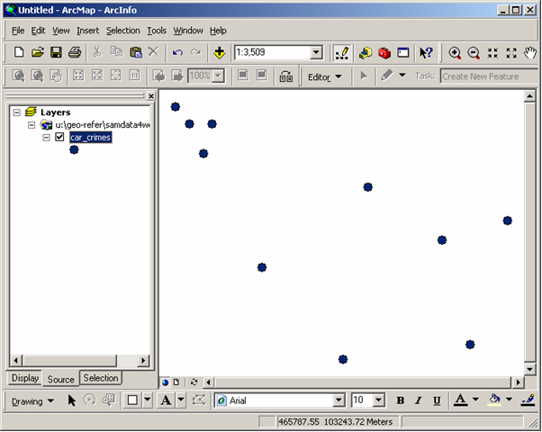
Your points are now mapped!
NB. To help you keep track of the files that you have created, it is probably worth tidying up and
removing any files which you no longer need. You could therefore remove the "CRIMES Events" layer and
the "CRIMES" table from your Map now by right-clicking on them and selecting "Remove".
Copyright Attribution
ArcGIS® and ArcMap® are registered trademarks of Environmental Systems Research Institute, Inc.
(ESRI). dBASE is a registered trademark of dBASE Inc. and Access™ is a registered trademark of
Microsoft Corporation. The software screen shots shown in this page are reprinted with permission from
ESRI and Microsoft Corporation.
 Homepage