Copyright Attribution
ArcGIS® and ArcMap® are registered trademarks of Environmental Systems Research Institute, Inc. (ESRI). The software screen shots shown in this page are reprinted with permission from ESRI.
 Homepage Research Staff Publications Useful Links
 Within ArcGIS, every dataset has a coordinate system which is used to integrate it geographically with other layers. It is important that the user ensures that all datasets which they wish to use for a particular map or series of analysis are projected according to the same coordinate system. Within ArcGIS, coordinate systems are classified either as geographic coordinate systems (such as latitude and longitude) or projected coordinate systems (such as the British National Grid). For the sorts of mapping and linking tasks commonly undertaken by social science researchers, one of the standard world, continental or national grid projected coordinate systems is likely to be the most appropriate.
Note that it is possible to map data without having defined a coordinate system (ArcGIS will inform you that your data do not have a spatial referencing system defined but it will enable you to proceed and map the data without defining one), but this will only be plausible if all of your datasets are for the same geographical area. Also, if you wish to undertake any spatial analysis involving the calculation of distances, areas etc. you must define a coordinate system. In general, it is good practice to define a coordinate system, even if you are not going to specifically undertake spatial analysis.
In some instances, data will be supplied with a coordinate system pre-specified. You can check whether this is the case by adding the data as a layer to your map in ArcMap (using the Add Data button or File >> Add Data), then right-clicking on the name of the layer and selecting Properties and then the Source tab. If a coordinate system is already defined it will be detailed in the Data Source window. If not, the coordinate system will be listed as Undefined.
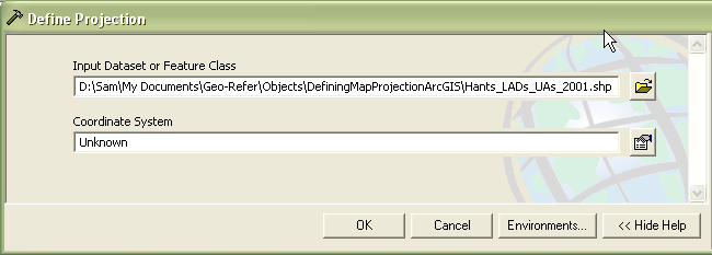
If your data do not have a coordinate system defined you will need to define one yourself. Open the Define Projection tool from ArcToolbox, which can be found under Data Management >> Define Projections and Transformations. Browse to and select the input file for which you wish to define a projection. ArcGIS will read your dataset and establish whether or not it already has a projection system defined. If it does not, the Coordinate System will appear as 'Unknown'.
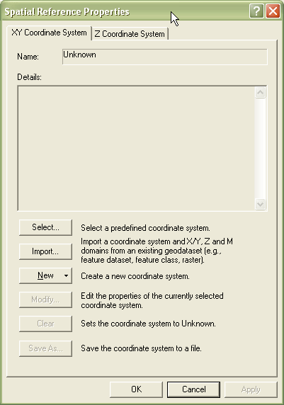
Click on the button to the right of the Coordinate System textbox. This will open up the Spatial Reference Properties dialog box which allows you to define the appropriate projection system for your dataset. Note that from this dialog box you can select a predefined coordinate system, import a coordinate system from another geodatabase, or define a new coordinate system. In most cases, you will simply want to select a predefined coordinate system.
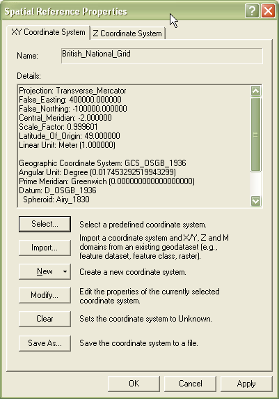
Clicking on the Select . button will enable you to browse for the appropriate projection system for your dataset. Select the relevant coordinate system and then click on Add (Hint: the British National Grid can be found under Projected coordinate systems >> National Grids >> British National Grid.prj). The details of the selected coordinate system will be shown in the dialog box window.
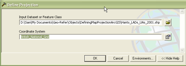
Clicking on OK will take you back to the Define Projection tool (this time with the relevant coordinate system selected for your dataset).
Finally, clicking on OK will set the coordinate system for your dataset. The Define Projection tool will start to run and a progress window will be displayed. When the tool has finished running, close the progress window. Your dataset will be displayed in the ArcMap window. You can check the coordinate system has been defined correctly by right-clicking on the Layer's name in the Table of Contents window, selecting Properties, and then clicking on the Source tab. The coordinate system will now be listed amongst the Layer Properties details.
ArcGIS® and ArcMap® are registered trademarks of Environmental Systems Research Institute, Inc. (ESRI). The software screen shots shown in this page are reprinted with permission from ESRI.