 Homepage Research Staff Publications Useful Links
 The majority of phenomena or features which we wish to represent in social science research can be represented as three types of geographical objects: points, lines and areas (Figure 1(a)-(c) below). Points are generally used for events or features which occur at, or can be identified by, a specific location e.g. a general practitioner's surgery, supermarket or church. Linear features e.g. roads or public transport routes, which have distinctive start and end points and links or connections between them, are usually represented by lines. Finally, areas are used to represent features which have a regional or zonal extent bounded by a set of mappable boundaries e.g. a local government area or electoral constituency.
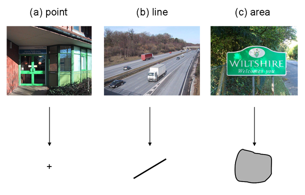
Figure 1: Geographical object types (a) Points; (b) Lines; and (c) Areas
In GIS terms, a point comprises a pair of coordinates usually in the form (x, y). A line is a series of ordered coordinate pairs representing the start and end of the line and, if appropriate, intermediate points along the line. An area (often termed a polygon in GIS) comprises a set of lines which close to form a polygon i.e. the first and last coordinate pairs must be the same. Figure 2 illustrates how points, lines and polygons are stored in a GIS.
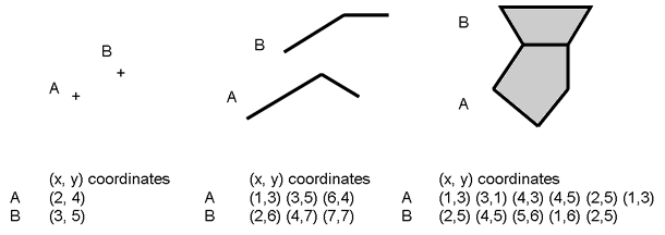
Figure 2: Coordinates stored in a GIS for different geographical object types
It is not always clear which geographical object type should be used to represent a specific feature or phenomenon. The decision usually depends on the purpose of the research and is often closely related to the scale of the study. The same geographical phenomenon could, with validity, be represented as different object types at different scales. For example, a town could be represented as a point on a small scale map, whereas at a larger scale the same town could be represented as a polygon delimiting the extent of the urban area, or even a collection of symbols representing individual buildings.
In some cases, geographical data for a particular phenomenon may only be available as a specific object type. This can mean that even if a researcher would ideally represent the phenomenon as one object type this may not be possible. An example is where only a set of centroid points is available to represent a set of geographical areas.
Note also that there are two extended object types: networks and surfaces. A network is an extension of the line object type but is used for the modelling of more complex linear features. Network models include features such as junctions, impedance and directionality and can be used for phenomena such as transport or utilities networks. Surface models are an extension of the area object type. Rather than treating features as discrete objects with distinct boundaries (as in the area object type), the surface object type represents them as continuous features. This is most appropriate for features which vary continuously over space, such as elevation and population distribution.